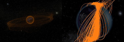
With more and more man-made objects orbiting the Earth – most of them junk and high velocity debris – space travel and maintaining satellite orbits is becoming increasingly problematic. To illustrate the dangers of the more than 12000 tracked (and 600000 estimated) objects, ESA uses InstantReality to visualize the distribution and temporal variation of these objects. The results can be viewed either in real time, but they have also been compiled into an informative video, which is available at the ESOC in Darmstadt.
Archive for the ‘Exhibition’ Category
Space Debris Visualization
Wednesday, January 27th, 2010Augmented Reality Sightseeing
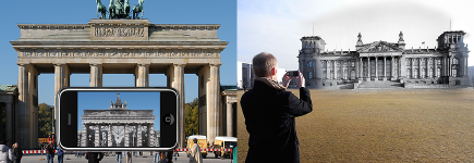
Tuesday, January 26th, 2010At CeBIT 2009 Fraunhofer IGD presented Augmented Reality technology for assistant living using the example of Berlin. Center of the project was a table with a satellite image of Berlin on which a 3D model of the Berlin Wall and the urban development from 1940 – 2008 are displayed. Therefore urban grain plans showing areas covered with buildings is augmented on the satellite image. The visualization was presented on UMPCs and the iPhone via video seethrough.
Furthermore posters showed the system working outdoors. Historic photographs are seamless superimposed and showing the development of landmarks. The interface is kept very simple by fading in information and overlays context and location-sensitive.
Educational 3D Visualization of Astronaut Motion in Microgravity
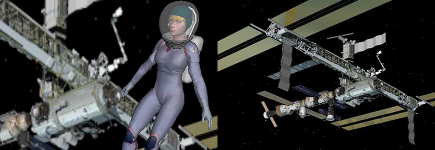
Monday, January 25th, 2010In this joint project of the MIT Department of Aeronautics and Astronautics and the MIT Office of Educational Innovation and Technology, researchers collaborated with visual artists to create three-dimensional visualizations of astronaut motion in microgravity. Through the graphical user interface, which is implemented in X3D, students can interactively explore how astronauts rotate in a microgravity environment without using any external torques, i.e. without contact from the surroundings. These rotations are simulated with results from recent research in astronautics [Stirling, Ph.D. thesis, 2008] using mathematical algorithms that implement core curriculum concepts, such as conservation of linear and angular momentum. The computer character, which was modeled and texture-mapped in Maya®, wears a next generation astronaut space suit which MIT researchers develop for NASA.
Radiohead’s ‘House of Cards’
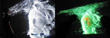
Sunday, January 24th, 2010Radiohead released the 3d data of their video “House of Cards” under the Creative Commons license. We wrote a converter script that creates an animated ParticleSet from the csv point data. The result is a real-time rendered music video you can walk through. The new Heyewall 2.0 renders the data on a 8160 x 4000 pixel resolution.
Multi-Touch 3D Architecture Application at CeBIT 2008
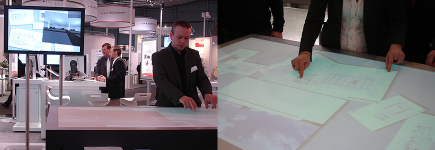
Saturday, January 23rd, 2010IGD’s multi-touch table application for visualization of 3D architectural models presented at CeBIT 2008. It features several scalable architectural 2D plans. Multiple users can move and zoom these plans like you know it from other multi-touch applications.
But the key feature is the tile with a high quality 3D view of the building. We implemented the multi-touch 3D camera gestures we introduced last year: You are grabbing a plan with the left hand. One finger of right hand moves the camera through the 3D model. The second finger defines the orientation of the camera. This enables incredible cinematic camera movements in 3D. When the second finger points on a certain object on the plan and the first finger moves around it the 3D camera moves around that object while keeping it on focus.
iTACITUS
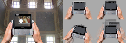
Friday, January 22nd, 2010iTACITUS is a sixth framework programme project and aims to privide a mobile cultural heritage information system for the individual. By combining itinerary planning, navigation and rich content on-site information, based upon a dispersed repository of historical and cultural resources it enables a complete information system and media experience for historical interested travellers. IGD’s part is the development of a “Mobile Augmented Reality (AR) Guide Framework” for Cultural Heritage (CH) sites. The framework delivers advanced
markerless tracking on mobile computers as well as new interaction paradigms in AR featuring touch and motion capabilities. In addition to visual components like annotated landscapes and superimposed environments the framework will feature a reactive accoustic AR module.
VRAx
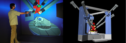
Thursday, January 21st, 2010VRAx® denotes a platform for designing machine tools that is based on Virtual Reality (VR) technologies analogous to existing CAx tools. VR technology is used as an active development and design medium in this process, and data created in VR are recirculated into the overall development process. Variants of machine tools with parallel kinematics can readily be created by combining a modular approach with free modeling functionality. This reduces the development times of new machine tools by the direct implementation of the customer’s wishes in an immersive environment and with considerably increased transparency of the development process. This is achieved by consistent integration of VR into the development and design process. Starting from a building block system of components of machine tools with parallel kinematics (PKM), functions for freeform modeling and optimizing the machine structure become available.
ParaMEDIC at SuperComputing 2007
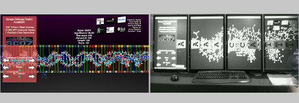
Wednesday, January 20th, 2010Virginia Tech’s ParaMEDIC (Parallel Metadata Environment for Distributed I/O and Computing) won the Storage Challenge at IEEE/ACM International Conference for High Performance Computing, Networking, Storage and Analysis (). ParaMEDIC is a high-performance and portable framework to decouple computation and I/O in applications that require large quantities of both resources simultaneously. The visualization at the Virginia Tech’s Booth was rendered on 4 monitors with instant player and on one monitor in Argonne National Lab’s booth.
Augmented Reality Measuring System
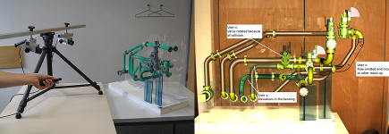
Tuesday, January 19th, 2010In order to identify differences between physical and digital mock-ups, which do not match exactly, and to transfer those differences back into CAD format, we developed an AR based measuring system. The system allows matching the CAD data with real mock-ups and documenting differences between them. Essential functions like measurement and online construction are provided, allowing the end-users to create information in AR space and feeding them back into the CAD model. The application was developed within an authoring tool based on the instant*reality*-framework. Furthermore, it was presented on ISMAR ’07. The tool was developed for the needs of the submarine engineering of (Howaldtswerke – Deutsche Werft GmbH), who also funded the project.
Coperion Visualization at K Fair
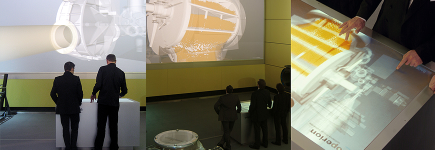
Monday, January 18th, 2010We developed together with Design and Systems Institute a technical information visualization based on our multi-touch table and an 8 meter wide HD projection. The complete interactive plastics production process was presented at K trade fair on Coperion group’s (global market leader for compounding systems) booth. It enables users to see and understand complex and invisible processes inside the machines via a simple multi-touch interface.
